The Arakawa Floodway 荒川放水路 is one of Tokyo’s most significant and enduring civil engineering projects.
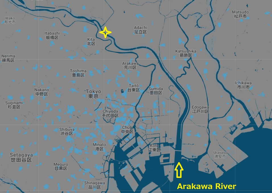
In response to massive flooding of the Arakawa River 荒川 in 1910, the government embarked on a project to divert part of the river into a man-made channel starting at Iwabuchi 岩淵, near Akabane in Kita-ku. This resulted in the Arakawa being widened and pushed to the east in what would be called the Arakawa Floodway or Arakawa Drainage Canal (this stretch of water is now simply referred to as the Arakawa River). While the main flow of the Arakawa would follow the floodway, the remaining flow would follow the original path of the river; this stretch was renamed the Sumidagawa, which flows directly south into the heart of Tokyo (source).
Seen today, the Arakawa Floodway is clearly a wide and significant waterway:

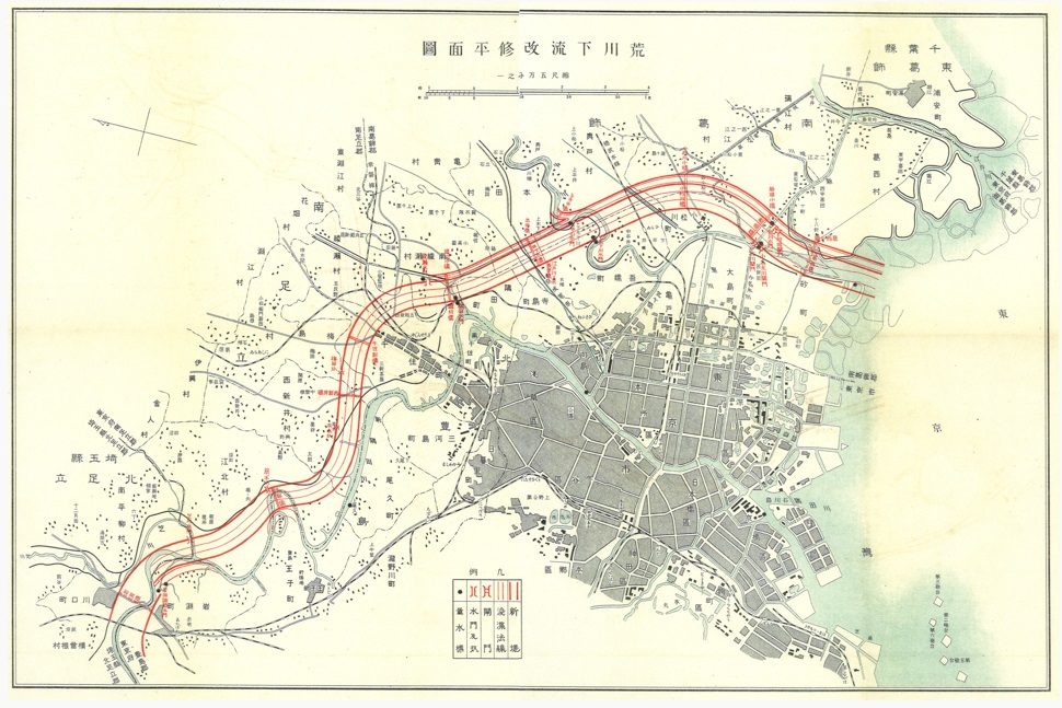
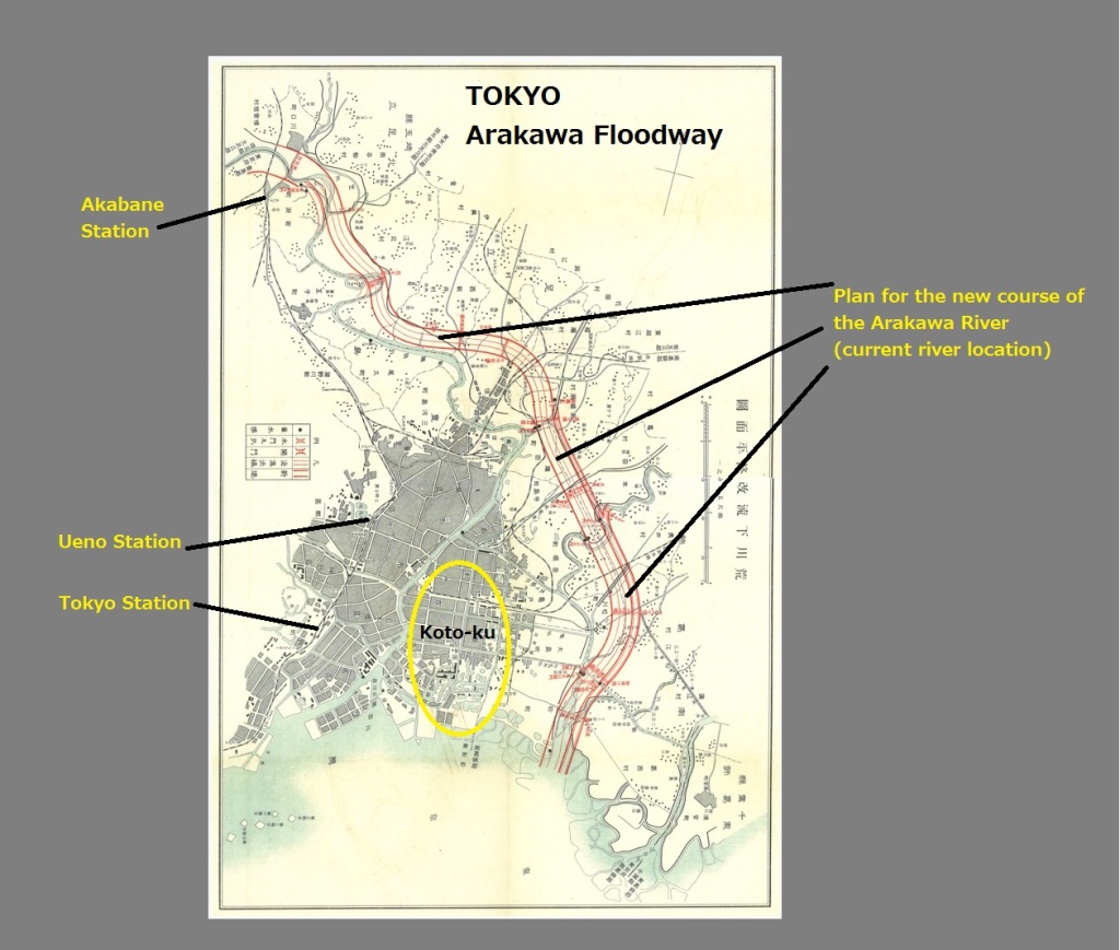
The project was led by Akira Aoyama 青山士, who had recently returned from the Panama Canal, where he had been the only Japanese national working on that project. The Arakawa floodway is 22-kilometers (14 miles) long, just one-quarter the length of the Panama Canal (82 kilometers). The following plan is shown in its original format (source), and edited to show north at top (with annotations).
In 1924, a major element of the project was completed, which regulated the flow of water between the Arakawa Floodway and the Sumida River. This was called the Iwabuchi Floodgate 岩淵水門 (Iwabuchi Suimon), aka the Red Floodgate 赤水門 (Akasuimon). (Suimon 水門 can be translated as Water Gate / Floodgate / Lock Gate / Sluice).
The old Red Arakawa Floodgate today (map):

While the old Red Gate is now purely decorative, a new blue gate takes its place, known as the New Iwabuchi Floodgate 新岩淵水門 (Shin-Iwabuchi Suimon), or the Blue Floodgate 青水門 (Aoisuimon).
The new gate (map):

Close to both of the floodgates is the Arakawa River Flood Control Museum 荒川知水資料館アモア (aka Arakawa Museum of Aqua 北区役所 荒川知水資料館), which has an exhibit on Akira Aoyama and the floodway, including this amusing diorama (source):

Directions / Access
You can reach the floodgates and the museum via a 1-kilometer walk from Akabane-Iwabuchi Station 赤羽岩淵駅; Akabane Station is also shown in the bottom-left of the following map (source).

Sources, Notes, and Links:
From The Japan Times, “Much about nothing in Akabane Iwabuchi“:
“Neither Junko nor Satoe wallow in self-pity, though. Junko implies that living close to the Arakawa River automatically inures one to hardship. “That river used to rise often, flooding and killing people. It’s managed better now, with sluice gates,” she says, referring to the 1924 completion of the Akasuimon floodgates, and the newer gates installed in 1982. “But I can still remember several floods.'”
Links:
- (27) River embankments and floodplains 堤防と氾濫原
- Kawaguchi Art Factory and the Red Sluice Gate 岩淵水門
- Akabane Station, Kita-ku & Iwabuchimachi: water, tunnels and liberty
- splashing around Tokyo’s water infrastructure
- Arakawa River Floodgate, circa 1940
- Overview of Tokyo’s rivers
- Excellent deep-dive of the river: The Arakawa River
- Tokyo Infrastructure: Arakawa Floodway
- The Story of the Arakawa Floodway
- Flood control
- Note on language: the word 放水路 = water discharge route / floodway; an artificial drainage channel / canal that branches from a river to discharge it into the ocean, etc., to prevent flooding = hōsuiro ほうすいろ (aka 分水路 = bunsuiro ぶんすいろ).
- “Urban Water in Japan“, edited by Fransje Hooimeijer Rutger de Graaf: “This project involved construction of a floodgate at Iwabuchi and a massive diversion channel, which is called the Arakawa floodway.”

See also:
- The floating world of floating logs: the kiba of Koto-ku
- Map of new river channels in east Tokyo, from GIS-Based Visualization of Tokyo’s Urban History (PDF)


[…] https://thetokyofilesurbandesign.wordpress.com/2018/09/14/arakawa-floodway/ […]
LikeLike
[…] Here is Iwabuchi sluice 岩淵水門 , a floodgate (suimon) that regulates the flow of water between the Sumidagawa and the Arakawa Rivers. See also: Arakawa Floodway 荒川放水路 […]
LikeLike
[…] 荒川 Arakawa River (Arakawa Floodway) […]
LikeLike
[…] Arakawa […]
LikeLike
[…] Arakawa Floodway 荒川放水路 […]
LikeLike
[…] the sediment left by the Sumida River as it emptied into Tokyo Bay. In the early 20th century, the Arakawa River Floodway was added, and Koto-ku is now nestled between both […]
LikeLike
[…] Map of the Musashi Canal, which connects the Tone River (Tonegawa) to the Arakawa River. […]
LikeLike
[…] Ayase River (Ayasegawa) 綾瀬川 is a river in Saitama that eventually flows into the Arakawa River (after briefly joining the Nakagawa). Per Wikipedia, pollution has been a problem in this […]
LikeLike