Spend some time with the history of Tokyo and you soon learn that the central city, particularly from the Imperial Palace to Koyo-ku, is built on and around a system of rivers and canals, many of which have since been filled-in. These waterways largely disappeared after World War II, but prior to that time, central Tokyo was dominated by moats and canals from the Edo era. These waterways are visible in a map of Edo-era Tokyo, annotated below (north is to the right):

Points of interest include:
- Imperial Palace
- Ueno & Shinobazu Pond 不忍池
- Ginza 銀座
- Asakusa Okura warehouses 浅草御蔵
- Ryōgoku Bridge 両国橋
- Eitabashi Bridge 永代橋
- Present-day Koto-ku, which still exists as a city of canals
The wide Sumida river is a clear dividing line between the main part of central Tokyo (e.g. the Imperial Palace, Ginza, etc.) and the area on the opposite bank (which includes the location of today’s Ryogoku Sumo arena). One of the important bridges that spanned the Sumida River was the Ryogoku-bashi 両国橋. The name of the bridge illustrates its importance; per Wikipedia, “In 1659, the Ryōgoku Bridge was built, spanning the Sumida River just upstream of its confluence with the Kanda River 神田川. Its name, meaning “two provinces,” came from its joining Edo (the forerunner of Tokyo in Musashi Province 武蔵の国) and Shimōsa Province 下総の国. The district derived its name from that of the bridge.” (Also of note: lots of the water that used to flow to Tokyo Bay via the Edo River was diverted east via the Tonegawa River during the “Eastward Transfer Project” in the 17th century.)
Map of Shimosa Province 下総の国 (source):
There was obviously no subway back then, so anyone wishing to cross the river would need to do so by boat or by bridge. (Today, though it is far easier to cross the Sumida-gawa, the river still creates a large psychological barrier between the greater-Ginza area and Koto-ku; the Ginza is considered cosmopolitan, one of the “hearts” of Tokyo, whereas Koto-ku is considered a somewhat boring, residential area).
The bridges of the Sumida-gawa became vibrant settings for human activity, which was chronicled in woodblock prints such as Hokusai’s 江都両国橋夕涼花火之図 Fireworks in the Cool of Evening at Ryogoku Bridge in Edo, or Hiroshige’s View of Ryogoku Bridge, the famous place of Edo 広重三代「東京名所両国橋之図」.


The excellent Tokyo-Edo Museum has a diorama of Ryogoku Bridge 江戸東京博物館の両国橋ジオラマ that illustrates how the townspeople interacted with the bridge:


The culture of the bridge is a center-point of the animated film, Miss Hokusai 百日紅 (Sarusuberi):

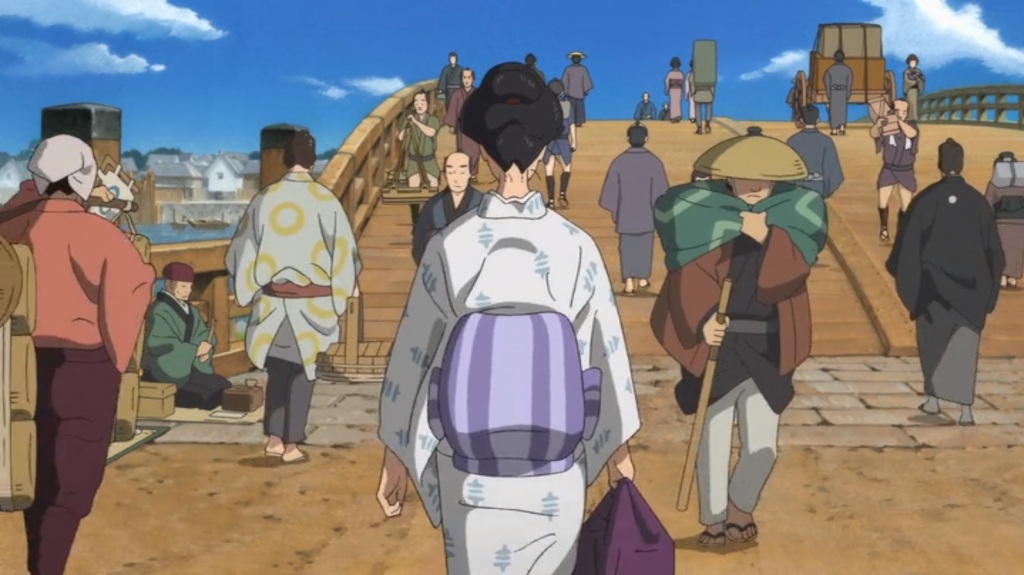


The Asakusa Okura warehouses (kura) 浅草御蔵, mentioned in the map earlier, are clearly visible at the left side of the next few frames (this is near the present-day Kuramae Station 蔵前駅:


Finally, in the wide shot below, we see the mouth of the Kanda River at left; the second frame is a pleasant scene in a boat under the Ryogoku Bridge.


See also:
- Maps of Edo-era Tokyo: a focus on water
- A mystery along the Sumida River: A fishing village, then a Sky Tree mystery
- Old Ryogoku Kokugikan 旧両国国技館
- Tonegawa Eastward Transfer Project 利根川東遷事業
Other Sumida River bridges:
- Photos of the bridges: The bridges across the Sumida River
- An excellent resource: Tokyo Bridge Club 東京の橋クラブ – Maps of nearly every bridge that cross Tokyo’s rivers; here, the Sumida River
- Sumida river and many bridges, Tokyo
- Several photos of Kachidoki-bashi: Japanese Film Noir: Meteor 流星 (1949), and Kachidoki-bashi 勝鬨橋 drawbridge
- Kachidoki-bashi in 1970; Tsukiji Market and Tokyo Tower in the distance
Related topics:
- Up the river: Akabane Station, Kita-ku & Iwabuchimachi: water, tunnels and liberty
- Another annotated map: STUDY IN EDO: SHIBATA SHŪZŌ (1820–59) AND STUDENT LIFE IN LATE-TOKUGAWA JAPAN
- Koto-ku walking map: Onagigawa & Higashi-Ojima
- The floating world of floating logs: the kiba of Koto-ku
Bridges and River Cruises:


[…] Ryōgoku Bridge & the Sumida River […]
LikeLike
[…] current site of the Ryougoku Sumo Hall (Ryogoku Kokugikan 両国国技館) (map). The physical location of Ryogoku is interesting; the name means “two provinces,” which refers to how, during the Edo period, this location […]
LikeLike
[…] Ryōgoku Bridge & the Sumida River […]
LikeLike
[…] Ryogoku (home of the sumo stadium and Ryōgoku bridge) […]
LikeLike
[…] Tokyo-Edo Museum 江戸東京博物館 is good one-stop shopping for Tokyo history. Here is a diorama of Ryogoku Bridge 江戸東京博物館の両国橋ジオラマ that illustrates how Edo’s […]
LikeLike
[…] employees. The original building may possibly be visible in this aerial photo of the Sumida River from 1945/1950 […]
LikeLike
[…] Ryōgoku Bridge & the Sumida River […]
LikeLike
[…] 23 main wards *. Koto-ku is essentially a river delta, formed from the sediment left by the Sumida River as it emptied into Tokyo Bay. In the early 20th century, the Arakawa River Floodway was added, and […]
LikeLike